READ NOT. This is too much exposure and I don’t know if I can still handle. A glimpse of my life being parted each time I write and I am not keen of it. I knew myself before, but now, I don’t know what happened; the more vulnerable I become. Lost for words…….don’t know ……….where to start….just… lost.
…we’re almost there – a sigh of desperation. Barely hanging on to mud-covered pathways, horses’ poops, and 6% phone battery. We are WET. We have plenty of water but what we need is LIGHT… as the clouds concealed the sun and we’re not even half way down. Our stomachs filled with goto (rice porridge) and buko (coconut) juice as we descended 45 minutes after 6; late but we have no other choice.
Hours back, we were startled of the trail not that of the road but that of the rainbow. Indeed, we are beginning to question luck and fate for this unfathomable series of events. Stranded at the 9th peak with the locals, we are still hoping to finish the 10-peak mountain. The shed where all the wetness took place (hahahaha, can’t help but laugh). Damn Bagyong Utot! =)
Frigid and quivering…little chitchat and funny stories…giggles and juvenile acts…made this trip the best one yet.
Random Hashtags regarding Navigation:
#SinoSiKuyaTot?! Kuya Tot, single, a hired tour guide for a fee of PhP250.
#KailanganPaBaTalagangMagTourGuide?! Even a novice can navigate the mountain even without a paid tour guide. The trails are easy to follow and if in case you get lost, there are a lot of backpackers traversing the mountain on whom to ask for directions. On top of this, you can also ask the locals since there are kubo (huts) in every peak selling buko juice, halo-halo, and goto.
#BakitKailanganMagTourGuide?! They are doing it for their family. The money they earn from guiding tourists is being used to buy rice and other necessities. Main livelihood of the residents here is farming crops such as kamote (sweet potato). It is just one of the means to help them. =)
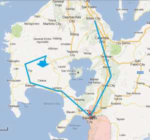
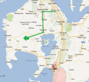
#PaanoKamiNakadatingDito?! I will not disclose the details anymore as we are not credible enough to advise on how to go there. Hahaha. Let these pictures illustrate:
What We Did (refer to Blue Line)
What Should Be Done (refer to Green Line)
Our PhP500 budgeted trip turned into mayhem with this unexpected round of events. Anyways, this is the original plan on how to go there? (easiest way if via public transpo):
Take the Nasugbu-bound buses at the terminal in EDSA-Taft which is located at the intersection of MRT3 and LRT1 railways near McDo and Jollibee. It will be 2 to 3 hours ride depending on the driver’s rate. Ask the conductor to drop you off at the Evercrest. From there, take a tricycle to the jump-off point for PhP100 (maximum of 4 persons).
Every yearend, the sun sets right between Batulao’s two peaks, creating an image of rocks surrounding a disc of red light. In Tagalog, this phenomenon of “Bato sa Ilao” (Illuminated Rocks) became abbreviated to “Batulao”. Although this happens only in the last week of December, Batulao’s charms throughout the year are more than enough to make it among the favored mountaineering destinations. Source: http://www.pinoymountaineer.com/2007/08/mt-batulao-811.html
“Nagsimula ang lahat sa Cookies and Cream at Super Chocolate na ice cream. Naplano ang lahat para mairaos ang kaarawan ni Pink Ranger sa buwan ng Abril. Nagtiwala kay Ada at sa kanyang makabuluhang pakikipagsapalaran. Naligaw ng landas at naikot ang buong Batangas. Napariwala sa piling ng mga kababayan at kaibigan. Subalit datapwat, di mapapalitan ang karanasan na ating natunghayan. Kay sarap ballikan at itama ang ating kamalian. Ika nga, ‘only lessons learned’. Salamat sa oras, pasensya na sa pagkukulang, at kita kita sa muli nating pag-akyat!” =)


